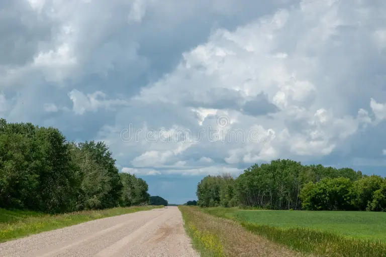
Cheers to a successful home sale!! Congratulations to both the buyers and sellers on this exciting new chapter in your lives. May your new journey be filled with happiness and cherished memories!
Cheers to Phyllis Tate on sealing the deal! 🏡🎉
The Preferred way to buy & sell real estate for you
Cheers to a successful home sale!! Congratulations to both the buyers and sellers on this exciting new chapter in your lives. May your new journey be filled with happiness and cherished memories!
Cheers to Phyllis Tate on sealing the deal! 🏡🎉
Are you dreaming of a country life, surrounded by nature’s beauty and nestled between charming towns? Look no further than this 78-acre haven, a hidden gem bordered by mature oak trees and lush pastureland, a landscape that seamlessly combines rural living with modern comforts.
A Natural Oasis:
As you step onto this property, the first thing that captures your attention is the breathtaking mature oak trees swaying in the Texas breeze. They not only provide shade but also create a sense of tranquility that can only be found in the countryside. The land is fenced and cross-fenced, ensuring security for your livestock and creating distinct, functional areas within the property.
Green’s Creek meanders through the landscape, enhancing the property’s charm with a beautiful pecan bottom, where mature pecan trees thrive. This slice of paradise is not just a homestead; it’s a thriving ecosystem, inviting local wildlife, including deer, to call it home.
Charming Country Rock Home:
At the heart of this property, a rustic country rock home welcomes you with its warmth and character. Featuring 3 bedrooms and 2 bathrooms, this cozy home provides the perfect blend of comfort and functionality. A brand-new HVAC unit ensures year-round comfort for you and your family.
The spacious living room is adorned with a rock fireplace, complete with a hearth and a built-in gun cabinet—a true testament to country living. Additionally, the entryway has a generously sized closet that can be repurposed as a small office, catering to your specific needs.
The separate dining room leads to a well-designed kitchen, complete with ample storage space and built-in appliances. Preparing meals in this kitchen will be a delight as you look out onto the beautiful landscape surrounding your home.
Equestrian Paradise:
For those with a passion for horses, this property is a dream come true. The barn on-site boasts seven stalls and a tack room, ensuring your equine friends are well-cared for. Pipe-working pens and covered feeding troughs are also available, making horse care a breeze.
Additionally, there’s a rock equipment barn, providing ample storage for your farming and ranching equipment, further enhancing the functionality of the property.
A Glimpse of the Past:
As you explore the property, you’ll discover remnants of history. An old rock bridge, once traversed by an old railroad track, still stands, offering a glimpse into the past and the rich history of this land.
The Ideal Lifestyle:
Whether you’re a cattle rancher, horse enthusiast, or simply someone seeking the beauty of the countryside, this property offers the ideal lifestyle. It’s a place where you can truly experience “Country Living at Its Best.”
Schedule a Showing:
Don’t miss the opportunity to make this 78-acre oasis your own. Contact Preferred Properties of Texas today to schedule a showing and experience the beauty, serenity, and endless possibilities that this property has to offer. Embrace the country life you’ve always dreamed of, right here between Stephenville, Dublin, and Hico. https://www.preferredpropertiestx.com/listings/new-listing-78-acres-of-great-horse-and-cattle-property/
All land owners are exposed to the risk of damage from natural disasters. A post-flooding plan is important for all land owners, especially if you live in a coastal area.
Your plan of action after a flood depends on the extent of flooding and the damage done. Your land type will also be a factor, as certain properties such as agricultural or timberland are more likely to suffer serious, long-term flooding complications.
Here’s what you can do in either case to help your land recover from the damage caused by flooding.
Step One: Assess the Damage
Do a thorough walkthrough of your property as soon as it is safe to do so. This will help you determine the extent of damage. Did the flood drown crops? Are there any large structures, such as trees, that have fallen? Take pictures and get a good overview of the damage.
Step two: Contact the appropriate parties
You can get help from a variety of professional parties. State and federal agencies can provide assistance in the event of a natural disaster, as well as cleaning agencies that are able to help with things such as salvage and debris removal. You should also call your flood insurance provider to begin the claim process.
Step Three: Get Rid of Standing Water
The longer water remains on your land, you are more likely to experience long-term problems like soil contamination and erosion. Sump pumps below ground can be installed in some areas to aid in water removal. However, they may not be suitable for all areas. If you are unsure, call a water removal specialist to help remove standing water and, if necessary, provide drainage options for affected areas.
Step Four: Test Soil
The post-flood cleanup doesn’t stop when your land is dried up. Flooding can have a big impact on soil. You’ll need test the soil and possibly rehabilitate it to get things back to the way they were. It’s best to test your soil after it has dried completely, as this will give you a clearer idea of what you are working with. You should pay attention to moisture levels, decreased Nitrogen, and below-ground debris. These are all things that you need to resolve if you want to see successful regrowth.
Step Five: Leveling the Land
Your post-flood plan should include a final step of leveling any areas affected by soil eroding or deposits. You should be strategic in your leveling efforts. This will not only fix the problem areas, but also prevent them from happening again in the future. Digging new channels or sloping some areas of your property could make a huge difference in the way water flows through your property.
It takes time to recover from a flood, especially if there is a lot of work involved in rebuilding and replanting. Accept help, be patient, and take steps to flood-proof your land in the future. This will ease stress and allow you to get back on track sooner.
You probably haven’t thought much about the boundaries of your land since you bought it, unless you are in a dispute over a fence or an overgrown garden. There are no lines on the ground that show where your property ends and begins your neighbor’s.
The importance of parcel boundaries is not limited to neighborly disputes. They are also important in thousands of business, legal and government decisions made every day. Here are five things you might not know about parcel boundaries.
A parcel is land that has a parcel boundary. The parcel boundary is a perimeter that determines how the parcel will look.
A parcel can be defined either as a point or a shape. A boundary can be translated onto a map as a polygon. No matter how many angles or curves there are, the shape allows for a complete definition. A parcel can be defined by a point located on a map using latitude andlongitude. Sometimes only one point is defined per parcel. This point can have different levels of precision. It could be the rooftop or centroid (the point in the middle of a parcel), or even a zip code. It is important to keep in mind that no matter how precise the latitude/longitude point, it does not tell the entire boundary story.
There are many reasons why parcel boundaries matter. Here are just a few of them:
Different industries require parcel boundaries for different reasons.
In land records management parcel maps are used to show the exact location of each parcel boundary. These maps, also known as assessor maps, allow anyone to see the boundaries of their property. These maps are used by county assessors to determine the size of land, which impacts value and tax amounts. They use shape to track the ownership of each piece.
Utility companies like gas and electricity may need to identify properties which could be affected by a power outage, or find the best place to lay new cables, wires, or pipe.
Lenders might want to know which properties in their portfolio have been affected by a disaster. Title companies may also need to calculate the distance from a potential danger, such as a gas station, industrial area, or a landfill.
Parcels used to be drawn on large-format paper maps. Assessors would write on each parcel a unique identifier (sometimes called an Assessor Parcel Number, or APN), which was used to track the parcels for tax purposes. Most counties now have a Geospatial Information System (GIS) department that uses mapping software instead of paper to create and maintain parcel borders. Digital maps not only make it easier to manage changes but also make them available online.
First American Data & Analytics holds nearly 2.5 million Assessor map in more than 1,100 counties. These maps cover 70% the U.S. populace, but we have 148 million parcel boundaries in almost every county. As with all First American Data & Analytics data from public records, we link these parcel boundaries to taxable areas defined by the Assessor. Some parcels are not taxed. Federal land, state park, tribal land protected forests, bodies water, streets, railways, and government building are some of the types that don’t get taxed.
Parcel boundaries can be updated through sales. This is important for tracking changes in parcel boundaries. It is important to keep track of these changes by having the most recent parcel boundaries. First American Data & Analytics updates parcel boundaries every quarter and is working to implement solutions that will allow this to happen more often. The fact that the county department responsible for recording documents does not maintain the boundaries is one of the challenges in managing a database. It is therefore possible that changes in parcels and owners due to sales are not in sync the actual parcel boundaries found on the county GIS website. First American Data & Analytics corrects the issue by using Public Record Data. This ensures that the correct owner is associated with a shape and points of a parcel.
First American Data & Analytics simplifies your job by focusing on accuracy and completeness when collecting and curating parcel information. Since decades, we have collected Assessor maps and Public Record Data and have focused on parcel boundaries and specifically linked them to the right properties because we know their importance to our customers. First American Data & Analytics, with its parcel boundaries and public records data linked together, offers a one stop shop for all the best tabular and spatial property data.
Original Blog: https://dna.firstam.com/insights-blog/5-things-to-understand-about-parcel-boundaries
Are you yearning for a piece of land that offers both natural beauty and potential for various endeavors? Look no further than this 326-acre property nestled in the heart of the Palo Pinto hills, just off I-20. This captivating property is more than just a piece of land; it’s a canvas of opportunities waiting for you to paint your dreams upon.
A Thriving Cut Stone Quarry with Endless Possibilities
Currently an active cut stone quarry, this property boasts a rich deposit of high-quality sandstone rock—a prized material in both construction and landscaping. With all the necessary permits and licenses in place, the operation can seamlessly transition to its new owner, ensuring a smooth continuation of business. If equipment is required, it’s available for separate purchase, streamlining the process and facilitating a seamless transition.
Nature’s Beauty at Your Doorstep
But there’s more to this property than its industrial potential. The Palo Pinto Hills offer a mesmerizing backdrop of rolling hilltops that gently undulate into the horizon. These hills grant you awe-inspiring views of the surrounding countryside, serving as a constant reminder of the natural wonders that envelope this land.
The property itself is a harmonious blend of woodland and verdant meadows. A mixture of hardwoods and pines creates a captivating tapestry of foliage that changes with the seasons. Throughout the property, you’ll find several small wet weather creeks meandering through, adding not only charm but also providing essential habitats for a variety of wildlife.
Endless Opportunities for Recreation and Relaxation
Imagine spending your weekends indulging in the joys of the great outdoors. This property is an oasis for those seeking adventure and relaxation alike. Whether you’re an avid hunter, a fishing enthusiast, or simply someone who craves the tranquility of camping beneath the star-studded Texas skies, this land can cater to your desires.
Additionally, if you’ve ever dreamed of building your own haven away from the hustle and bustle of city life, the stunning hilltop views offer the perfect canvas for crafting your dream home. Every day could begin and end with the breathtaking panorama of the Palo Pinto Hills as your backdrop.
Embrace Your Dreams in Palo Pinto Hills
The 326-acre property in the Palo Pinto hills presents an incredible opportunity to own a piece of land that’s not only functional but also teeming with natural beauty. From its thriving cut stone quarry to its rolling hills and tranquil creeks, this property is a playground for those with vision and an appreciation for the great outdoors. Whether you’re looking to invest in a prosperous business venture or to create your personal haven, this land welcomes you with open arms.
Don’t miss out on the chance to own this slice of Texas paradise. Contact us today to explore the potential that awaits you in the Palo Pinto hills. We have tons of amazing new pictures to check out on our website! https://www.preferredpropertiestx.com/homes-for-sale-details/2141-BLUE-FLAT-ROAD-GORDON-TX-76453/20331513/51/
This parcel is 75.69 acres of beautiful land. This property’s interior is filled with huge fields, large oakes, and Pecan trees. The owner has focused on cultivating large deer herds and good hay-producing fields. The wooded half of the property offers great hunting and established deer. The other half is coastal and produces large amounts of round bales. There are older barns and an old dairy with a milking area on a concrete flooring with an office area or storage room. The large barn has 6 horse stalls, and a large storage area. Both buildings need some TLC. This barn has a working pen & chute leading to the round pen. The wood has been removed to preserve the round pen and will remain. Both barns have electricity. Both the older home and the guest house need some work. Both are surrounded by pipe & utility panel fence.